I was expecting Death Valley National Park to be all flat desert and sand dunes, and so I was surprised to find much more variety of terrain throughout the park. There were salt flats below sea level next to 11,000 ft mountains, sand dunes, and hilly regions with interesting desert colors in the rock formations.
Online photos posted: HERE
The first day as I entered the park I stopped mid-day at Zabriskie Point where a short trail to an overlook gave a view of magnificent desert hills with the salt-flats behind. Then I drove into the visitor center, passing below sea level. Interesting how there are 11,000ft mountains rising from the valley floor. Campsites were filling up, so I had to take the first available which was in the middle of a big RV parking lot.
I drove out and took a look at the Badwater salt-flats up close. At 282 ft below sea level, it is the lowest point in the US. Then I drove through the Artists loop which allowed some upclose views of the desert hills and the colors in the rocks. Finally I ended the day by driving up to the Dante’s View Point, (5700 feet) overlooking Badwater Basin (between 3 and 5 miles away, and almost 6000ft below) for sunset pictures.
Red line indicates Sea-level as seen from Badwater.

In the morning I got up before sunrise and went back to Zabriskie point for pictures. There were quite a few photographers gathered and so I staked my place for the sunrise pictures. As the sun rose, gradually illuminating the hills with the reddish early morning light, it was hard to tell if the lighting had peaked, or would get better, so I took a few too many pictures here.


Afterwards, I went for a run from Zabriskie point around the Gower Gulch loop trails, which followed mostly dry river beds weaving through the hills I had just photographed. The trail went 3 miles across to the edge of the basin on the other side, and then came back a different route. Some of the hillsides had holes from old abandoned mines. Much of the trail wasn’t marked and followed dry creek beds, leaving me wondering at times if I was on the right path. I saw occasional footsteps in the dirt indicating others had come through so I figured I must be on track. By the time I was done around 10:30, it was starting to get sunny and hot. 

For the second night, I moved my tent up to Stovepipe Wells campground 20 miles away. On the way there, I stopped at the Salt Creek Interpretive trail, which had some boardwalks to allow a short hike observing a shallow creek where tiny pupfish had evolved into a unique species. After reading and informational post on pupfish mating practices, I looked down and realized there were pupfish mating all over the place. Males would stake out prime spawning territory and drive off other males while trying to swim next to any female that came near to shake their stuff as the female laid eggs. Successful males were mating with two or three females within a few minutes. After spending a few minutes photographing this orgy, I walked through the rest of the loop trail. The vegetation in this area soaks up a lot of salt, and then old growth slowly dies turning a crisp white salty color. When I came back to the spawning grounds, all the activity seems to have stopped. It was as if I would have missed the mating season if I was 20 minutes later. Or maybe the little fishes got a room somewhere else.

When I got to Stovepipe Wells, I got one of the last tent-only sites on the edge of the campground that was a bit more secluded than the night before. I drove north up to Scotty’s castle, but missed the tour so I started back so I could be in position near the sand dunes for late afternoon pictures when the sun was low enough for interesting shadows. On the way, I stopped to get a picture of a coyote near the road. The coyote walked into the middle of the road and laid down. It did not get up when I wandered a little too close for pictures. It picked a spot in the road, just over a hill, where it was a bit dangerous because drivers would not see it until they were right up on it. It ignored every car that drove past, and everyone was stopping for a couple of pictures. At first I thought maybe it was wounded or sick, but it eventually got up and wandered off the road. I suspect someone might have fed this animal before, and now it was posing for pictures in the hopes of getting some food. 

I went to the dunes near my campsite and walked out a ways. Clouds were obscuring the afternoon sun, so the light was not good for pictures. I scouted out some paces to be for the next morning’s sunrise before heading back for a shower and early sleep. Back at the campsite, someone had taken my receipt off the camp post and replaced it with their own, despite my tent being up. The tent site boundaries were not well defined, and there was plenty of room and the other couple had pitched their tent more than 40 feet from me so after chatting with them a bit, I didn’t make an issue of it.
In the morning, I got up before sunrise and hiked into the dunes in the dark to be ready for the sunrise. There were a couple of other photographers on other hills, and we all did a fairly good job of hiding behind dunes to staying out of each other’s pictures.


After breakfast, I decided to get my trail run in at higher altitude as part of my training for Jemez, so I drove from sea level up to the Willow Peak trailhead at 7000ft. This would place me on the opposite side of Death Valley from my sunset vantage point of a couple of days before. I couldn’t hike to the highest point in the park, Telescope Peak at 11,000ft, due to snow, so I picked the next highest peak in the area. At the trail head, there were a bunch of large stone kilns build 100+ years before as a charcoal factory. The Sierra Nevada Mountains were visible in the distance. I ran up 4 miles to the peak near 9700ft. On the way up, I kept hearing what I thought was a nearby airplane flying near, but instead it was the sound of the wind blowing through the mountain passes. The wind had blown up a lot of sand from the valley below and obscured much of the views. The last mile has several patches of snow where I had to rely on previous hikers footsteps to figure out the path. I finally got to the top, but the wind was strong so I turned around quickly and descended to a saddle between mountains to take a quick lunch before running the rest of the way down. By the time I got down, the dust had obscured the Sierra Nevada’s in the distance.


The altitude effect of spending the night sea level and heading up to 10,000ft really started to hit as I drove away from the trail head. I did not realize it at the time, but this was a bit of training for my next trip to Hawaii. On the climb to the mountain top I had noticed a mild altitude headache, which is a little normal for me. Then on the drive down the mountain the pressure as my ears popped leaved me a little light headed. I stopped at one point to rest a few minutes and let the effects subside and drink some water. To leave the park, I had to drive down below sea level, and then back up over another 8000ft pass. By the time I got to Las Vegas, I was feeling rather fatigued from the headache that had come from these altitude changes. Stopping for food helped. And then I found a $23 hotel special at the Sands Casino on Vegas strip and crashed there early to sleep off the altitude sickness before moving on to Bryce Canyon the next day.
More photos posted: HERE
...Read the rest of this post...
Friday, June 19, 2009
Death Valley
Posted by
JohnF
at
6/19/2009
3
comments
Top of Page
Top of Post
Labels: North America, Travel
Wednesday, June 17, 2009
Travel Observations
I spent a 24 hour period on airplanes and in airports earlier this week returning home from Hawaii. Here are some miscellaneous observations.
...Read the rest of this post...
Collapse post (Summary only)...
Posted by
JohnF
at
6/17/2009
1 Comment
Top of Page
Top of Post
Labels: Travel
Thursday, May 21, 2009
Jemez 50k Trail Run
Several of us met Thursday to fly via Dallas to Albuquerque for the Jemez 50 mile or 50k Trail runs. I was in the 50k. It turned out to be the worst day to fly. When we arrived, the pilot hanging out in front of the airport gate warned us that backups caused by weather in Dallas would probably delay our takeoff four or five hours. We got it lucky. Once we took off almost 5 hours late, there were no additional delays. Throughout the day we heard stories of planes that, after circling Dallas for a long time landed in San Antonio to refuel before returning to Dallas. Others didn’t arrive in Albuquerque until late night or the next day. We lucked out by staying on the same plane through Dallas. The flight from Dallas to Albuquerque left with 80 people on standby after other flights to Albuquerque were cancelled. One lucky standby rider explained the earliest he could get a confirmed re-schedule was departing Dallas 8pm the next day. Good thing we came an extra day early in case we got stuck in that situation. We finally arrived in Albuquerque around 7pm and got dinner at a Mexican Restaurant that had been recommended before driving to Los Alamos for the night.
The combination of long delays, altitude and the Mexican food left me with a bit of altitude sickness Thursday night, similar to what I experienced in Peru a year before. But after I slept it off it went away and I took it easier the next day. Some of us took a tour of the Native American Ruins at Bandelier National Monument before going to packet pickup and the pasta dinner.
Photos:
- Jemez trail run
- Bandelier National Monument
Run Start to Mitchell Trailhead 4.2mi : 721 ft gain / 555 ft lost
Race morning, we gathered at the Los Alamos County Sheriff’s Posse shack for the start. I don’t think it is affiliated with law enforcement, but rather it is a recreational pavilion that can be rented out. The 50 Mile, 50k, and ½ marathon starts were each staggered by an hour. The 50k start began moments after sunrise. The first ¾ mile was on road and that allowed the crowd to thin by pace before going through a short tunnel under the road and then hitting the single track trail. The next 3 or 4 miles to Mitchell Trail Head went through some mild rollers in a section of forest that was damaged by the wildfires a few years back. Here the early morning light illuminated the area perfectly and I felt compelled to get a picture even though there was nothing in particular to photograph.
Mitchel Trailhead 4.2mi to Guaje Ridge 6.4mi : 1540 gain / 170 lost
After the first aid station, we began the first significant climb of 1500 ft towards Guaje Ridge. The whole mountainside had been burned by fire a few years ago, leaving lots of dead but still standing tree trunks and exposing views of the surrounding area. I took a few pictures upon reaching what turned out to be a false summit and then continued on to the top where there was another aid station. This was also the turn-around point for the ½ marathon race.
Guaje Ridge 6.4mi to Caballo Base 9.4mi : 835 gain / 1050 lost
It was a steep descent from Guaje Ridge along a narrow uneven trail. My extra weight compelled me to go a little faster when it was not too steep, otherwise holding back to be more cautions was hard on my knees. I could run most of the lengths of the switchbacks, but the turns usually sharp and involved a steep drop down a few feet to the next switchback and I had to take those one step at a time to avoid slipping. I passed Julia and Melissa in this section. Normally, they are much faster and I would never see them, but today they were taking this section slow and careful. Once at the base the trail flattened out and went a bit uphill.
There was a concrete Dam where we had to climb up a 12ft ladder. I found it good that I was holding only one handheld at that moment (the other was in my pack) so I could grab the ladder easier. Then the trail cris-crossed over a small stream several times. By the time I reached the Caballo base aid station it felt like I had gone a much shorter distance than 9.4 miles. At Caballo base, I was sorry to see another Austinite who I had met on the plane stopped due to altitude sickness. 
Caballo Base 9.4mi to Caballo Top 11.4mi : 1771 gain / 45 lost
Out of the aid station, there was a short climb and decent before the big climb. This was an out and back section so runners were already coming down. After a brief climb, the trail went down into a small gulley with a dry creekbed at the bottom before the big climb. Here, a runner coming down the mountain tripped on the trail 4ft above the gulley base where I was. I stepped aside just in time for her to land on her back and execute a fairly good roll and recovery. She stood up a little shocked but appeared to continue OK. What I didn’t know at the time was that in a few minutes there would be a bear sighting from this same area. Aid station volunteers would eventually be dispatched to “shoo” the bear away. I wasn’t aware of it until after the race when I saw some friend’s pictures.
After that I saw most of my training group coming down the mountain including those who would get pictures of the bear a few minutes after they passed me. It was a narrow trail and I kept having to stop to allow runners coming down to pass. I snapped off a few pictures of people coming down that I knew, but the camera did not always work out in the shade. I never got into a good pace. Melissa caught up and passed about half way up. Julia caught up a few minutes later and I kept her in sight until the top. A
hundred yards before the top, we left the forest for an open field with views of the surrounding area. The top, at 10,500ft, was the highest point on the course. There was a quick turnaround where someone had a camera set up for a photo, and then back down mountain the way we had come. 

Caballo Top 11.4mi to Caballo Base 13.4mi : 45 gain / 1771 lost
It is funny how the trail looks steeper on the way down compared to the way up. It was too steep in a lot of places for me to really run and my knees started to bother me on the steeper sections. I never saw Julia so I figured she was well ahead. It turns out she must have stepped off the trail since she came up behind me as I approached the gulley at the base. I passed only a few people on the way down, so I knew I was near the back of the pack. Somewhere in this section, my watch battery died so for the next 10 miles I had little concept of my time.Caballo Base 13.4mi to Pipeline 16.3mi : 1169 gain / 222 lost
Julia hadn’t made it to the aid station by the time I left, even though she was within sight a moment earlier. I knew she was worried the night before about bears and actually jokingly in my mind commented she must have been snatched by a bear when she didn’t appear at the aid station. It is a little funny since I was completely unaware that a bear had actually been spotted in the vicinity a short time before.
At first this section was not too bad and I was able to run a little. But then we hit the third big climb of the day that took us 100ft up. It was another steep climb that I could not run. I know I lost some time here. My calfs were burning. Julia caught up in the middle of this climb. Last time I was climbing mountains alongside Julia was almost one year ago exactly in Peru and so I had a moment of reminicing. She at first declined to pass me claiming to be no faster than me at this point. But once we hit a false summit and the trail widened she passed and quickly moved ahead out of sight. At the top of the climb the trail flattened out for a bit but my legs were fatigued from the climbs and descents, so I could barely muster a shuffle for the last mile or so into the aid station. This section felt a lot longer than 2.8 miles.Pipeline 16.3mi to Ski Lodge 19.2mi : 629 gain, 293 loss
Our Coach Robert was volunteering at the aid station and was about to leave to return to the finish as I entered. Several of my training group were had already been to Ski lodge and back and were heading out for the final 10 miles as I arrived. I took a quick detour to look out over the cliff edge where 50 milers had to descend into the Vales Caldera National
Preserve. But the 50k route instead was an out-and-back to the ski-lodge aid station over rolling hills and through an alpine meadow.
Again, I passed a few runners coming in the opposite direction and noticed some people must have dropped. When Melissa passed me coming back she said I had 1.25 miles to the end, so this meant she had gained 2.5 miles on me in a short time. Although I figured she sped up quite a bit once hitting runnable trail after the big climbs, still I knew that I had slowed much more than I realized without the benefit of a watch. Ski Lodge 19.2 to Pipeline 22.0mi : 293 gain, 629 loss
The aid station here had a bunch of good food and my drop bag. The 50 mile course meets up with us and follows the same course back to the finish. I had been carrying my pack with food, a wind jacket in case there was bad weather and with an extra water bottle that I had not used. So I left this pack in the drop bag and continued with only 2 hand held bottles and the gels I could carry in my pockets. I also got my spare watch here. A short distance from the aid station, I passed Robert who was hiking out from his aid station and then I walked a bit with a north Texas Trail runner. I never could muster a consistent run during this section. Maybe that is the price for taking the first decent hard and using up my quads. Photo at right from Jim Stein.Pipeline 22mi to Guaje Ridge 25.7mi : 316 gain, 1048 loss.
Even though this section was mostly downhill, there were a couple of steep climbs which I lost some time on. The first one came right after Pipeline where we followed a jeep track for a bit. My legs were shot, so I couldn’t bring myself to run hard on the downhills. But I kept moving to get it done. In this section we moved back into the region burned by the forest fires. 
Guaje Ridge 25.7mi to Rendija Canyon 31.0mi: 36 gain, 1792 loss
Although this is the same aid station we stopped at earlier, we follow a different course around the backside of a mountain towards the finish. Lots of 50 mile runners are passing me now. This area is rather exposed due to the fires, and cold wind starts to come in, but not too cold. We get a few rain drops but it never starts to rain. I can barely keep a shuffle going even though it is all downhill. I have to climb over a few fallen trees. Eventually I get down to an altitude even with the town of Los Alamos which can be seen on the next mesa over. I haven’t seen a trail marker or another runner in awhile so I ask a hiker who confirms I am still on the race course. The trail dips down into the valley between mesa’s, and I know what comes down must eventually go up to get to the finish. The final aid station at the bottom has a Christmas theme going, and the volunteers commented on how all these Austin runners kept coming out of the woodwork. 
Rendija Canyon 31.0mi to Finish 32.9mi : 426ft gain, 206 ft loss.
There is one nice climb out of the valley from the aid station. The uphills were feeling better for me than the downhills at this point and so I could accelerate a little until the course flattened out. The course crossed through the same tunnel as earlier, but then followed a different trail toward the finish. There was a relatively flat section here for about a mile. This whole section seems the longest 2 miles I’ve ver done. JT, who was running the 50 mile race, passed me in the last half mile, but I did not recognize him until he was further ahead. Then it was one last short steep rocky climb up through a wash and then a few hundred feet along the road to the finish which for me was 12 hours and 40 minutes.Finished!
There was barbeque at the finish, but it was not appealing at the moment so I did not partake of the finish line food. I went back to the hotel for a quick shower, and ate a couple of bananas and a cliff bar. Then we went back to the finish and a bunch of us hung out waiting for the rest of the training group to finish the 50 mile race. I heard stories from the other runners of the things that I missed such as sightings of fresh mountain lion footprints in the early miles of the trail, the bear sighting, and fresh deer kill.
This was a tougher course than I anticipated. Overall the weather was perfect. Cool, but not cold and it remained cool when the sun was out. Even though I was slower than anticipated, my main goal was to make it through the training and race without injury after recurring ankle sprains last year, and that goal was accomplished. I don’t know if I will come back, since there are many more races to try, but I would recommend it for people who want a challenge.
More Photos:
- Jemez trail run
- Bandelier National Monument
...Read the rest of this post...
Collapse post (Summary only)...
Posted by
JohnF
at
5/21/2009
4
comments
Top of Page
Top of Post
Labels: Race Reports, Running, Trail Running
Thursday, May 07, 2009
Davis Mountains
After my stopover at the Guadalupe Mountains last month, I originally was going to check out Big Bend Ranch state park. In this trip I was taking a week and a half to visit some state and national parks for Photography and also to get in some trail runs as part of my Jemez race training. After a long scenic drive I saw the signs said the highway was closed just east of the border town of Presidio. I stopped in the town to see if I could enquire if the park could be accessed before the road closure, but for all the signs indicating that the tourist information office was ahead, none of them identified the office. I stopped for gas and intended to ask the attendant if he knew where I could find info on the park access, but then while I was filling up watched some guy stumble out of the hotel next door and then collapse in the middle of the road. Wasn’t sure what was the cause, but he was soon surrounded by Police. I decided it best just to get out of there and go to my next stop for an extra day in the Davis Mountains.
After a stop for wine tasting at the Luz de Estrella Winery, I found a “camp room” in Ft. Davis that worked well. One wall was screened and open to the elements, with decent beds, sink with running water, and shared bathrooms. The room was a little more than a campsite but way less than nearby hotels so I took it. Then I went to the Davis Mountains state Park for a late afternoon run. At the entrance the ranger reviewed the trails around the park. When he was done I asked about the trails on the other side of the road that he didn’t mention. He explained those trails required a special permit and they don’t recommend them because they were so rough and rugged. How to I explain I have run at places such as Bandera and such trails are what I am there for. I decided immediately those would be the trails for the next day’s adventure and tonight I would run some of the more established trails and then get the camera setup for sunset pictures somewhere. Since I missed the hilly workout that my training group prescribed from the day before, I picked the hilliest looking trail and took off. After climbing some 400 or 500ft in ½ mile, I got to the top of a ridge and found myself running through a forest of desert plans that were taller than me. The late afternoon sun was perfect for pictures, though I only had the small camera for the run. Some of the trails were a bit overgrown and fading. I turned back on one that seemed to disappear but there were plenty of places to run for the time I had allotted to this workout.
Forest of desert plants
After the run I went over to an observation point to take pictures around sunset. I drove back and forth between a couple of observation points as the sun went down. This park is on the edge of two different types of terrain. To the west are the Davis Mountains, and to the east and below are the town of Ft Davis and flat desert terrain with a few more mountains in the background. Some of the cacti were flowering. In the distance, there was a huge indoor farming complex, the size of which became more apparent from this viewpoint compared to when I drove past it earlier. After the sun went down, I stopped off at the local BBQ place which was the only restaurant that still looked open. Despite being the only one there and arriving a couple of minutes before they closed, the staff was extremely hospitable. I ordered the food they recommended since I figured they were recommending it because it was the easiest for them to fix (so their cook could go home), I paid in advance (so the cashier could go home) and enjoyed a good BBQ mix of shredded chicken, pork and beef while the waitress mopped the floors.
The next morning I did a quick tour of the Ft. Davis historical site, and then went to get a permit for the “rough” trails in the state park for my next run. This time there was a different ranger who was much more enthusiastic about visiting that part of the park. Along with the permit I got the gate code for entry and went over there to start my run. There was one other car in this restricted access parking lot with a horse trailer, but I never encountered anyone on the trail. The trail was nice and secluded, but it did not live up to the reputation that the first ranger had indicated. While it wasn’t necessarily a “smooth” trail, the sotol was trimmed where it was growing across the trail, making this seem manicured compared to some of the places I have been running. After the initial climb to get up on the ridge, I got to a section where there was an earlier fire. The trail turned into the fireroad that separated the burned section from the un-burned. The trail eventually ended at an overlook point with views of the desert to the east. Overall it was a 7 or 8 mile round trip with a good climb in the middle.
The sotol was trimmed!
The trail separated burned from non-burned ground.
Overlook at the end of the trail
At night I went to the MacDonald observatory after sunset. My visit happened to coincide with the “Star Party”, which is a festival where they set up a bunch of telescopes at the observatory for the public viewing. Most of the crowd appeared to be locals, so I don’t think this happens very often. First, everyone gathered at the outdoor amphitheater for a brief talk. The presenter had the most powerful laser pointer I have ever seen. When he would talk about a star, the pointer would shoot a strong beam of light that appeared to go all the way to the star. I have a new appreciation for the concerns of pilots about being blinded by such devices. We also got to see an Iridium Flare predicted for that time. When Iridium was part of Motorola, I had a few occasions to talk to those involved in the development, but this was the first time I really got to see the results.
See more pictures in the online photo album HERE
...Read the rest of this post...
Collapse post (Summary only)...
Posted by
JohnF
at
5/07/2009
Leave a Comment!
Top of Page
Top of Post
Labels: North America, Travel
Tuesday, April 14, 2009
Guadalupe Peak
A few weeks ago, I took a week and a half vacation touring some state and national parks in the western US began with a stopover in the Guadalupe Mountains National Park. To save travel time, I had gotten flights from Austin to Las Vegas with a multi-day stop-over in El Paso, and from there was going to drive to a few parks in west Texas.
I have been to this park several times now, but most recently it has been with trail running groups so I never arranged to be at the summit of Guadalupe Peak with my camera gear for sunrise and sunset pictures. For this trip, I arrived around noon and got the last backcountry camp site on the trail to Guadalupe Peak. I packed up my tent, sleeping bag, and tripod, ate a tuna fish sandwich for lunch, and then began the hike up the mountain.
The last time I climbed this peak in 2006, it was during a training run. This time I was going considerably slower with the backpack full of gear. The climb is 4 miles to the summit, but the campsite was 3 miles into the climb. At 8749 ft, this peak is the highest point in Texas. The trail starts at 5800ft, and the first two miles of the trail are the steepest as there are tons of switchbacks climbing up the mountains. It is deceptive since these switchbacks show up as straight lines on most maps. Since they wrap around the folds of the mountain, you can never see how far they are from any one point. This makes it difficult to see how far you have come or how far you have to go even though the trail head remains visible below. After 30 minutes of climbing, I looked back to see that the parking lot was so close below it looked like I had barely gone anywhere. Damn.
After about an hour of climbing I stopped to take pictures and rest a moment. When I looked back, I saw the parking lot was still so close it looked like I had barely gone anywhere. Damn. I had climbed a little over 1200ft vertical feet and traveled a little over a mile according to the GPS device, but looking back on the parking lot it did not look like I had gone that far. 

Just under two miles in, I rounded a corner that put me on another side of the mountain. From there it was not so steep, and there was a little tree cover as the trail followed a mountain wall through an alpine forest. Still it took me awhile to reach the campsite at 8000ft. The ground was rocky enough that I could not get the tent stakes into the ground and the wind was a bit strong. There were some fixtures built into the tent site to tie down the tent, but I did not bring any string. I found one scrap piece of string left behind by another camper and used it to tie down one corner of the tent. Then I put heavy rocks inside at the corners of the tent hoping that would be enough to keep it from blowing away. It worked.
I had originally wanted to do some running hill repeats on the upper part of the trail after dropping my pack at the campsite to make up for missing the run workouts my training group in Austin was to do that day. Today’s workout was supposed to be a quality hill workout. By the time I got the tent setup, it was almost 5:00 and I needed to get to the summit to be there in time for the sunset. The run workouts would have to wait for the next stop on this trip. Even though I was getting a climbing workout on the hike, it wasn’t the same as running it.
I carried my tripod up the final mile to the summit. I got there in time for some of the good late afternoon picture taking light. The summit rises 300ft or more above the surrounding lands, making for a great view. There was enough haze that I could not make the pictures do justice to the view. I was up there for two and a half hours taking pictures as the sun went down and the light changed. I attempted some self portraits with the tripod and a timer while waiting for the sun to go down. 


On the way back after dark with a headlamp, I missed the turn-off from the main trail to the campsite. I could see lights from other’s tents on top of the ridge line, suggesting I might have missed it. I consulted my GPS indicated I had another half mile to go. But after a mile more of hiking down the mountain after dark, I knew I was going too far. I finally figured out that earlier in my rush to display the GPS map , I must have pushed a button that canceled the search for satellites after I turned it on so it was still indicating the position where I had previously turned it off to save battery. Once I figured that out, I was able to use the GPS to navigate back to the campsite. These bonus miles felt like a karma-like punishment for missing the run workout.
The next morning I got up early and returned to the summit before sunrise. Low clouds hid the sun, so I did not get the early warm light illuminating the scene. But it did make for some interesting sunrays beaming down through the clouds. On the way back, as I neared the turn-off to the campsite, I was looking for it determined to avoid the mistake of the night before. I ran into a couple who had hiked up early from the trailhead who told me they haven’t passed the camp site. So I backtracked and sure enough the turn-off was 15 yards behind me. I missed it again.


By the time I got packed up and carried everything down the mountain, it was almost 11:00, and time to drive towards my next stop in the Davis Mountains. I stopped once on the drive out to look back up on El Capitan and reflect on how far I had climbed up.
Link to more pictures: (HERE)
Collapse post (Summary only)...
Posted by
JohnF
at
4/14/2009
1 Comment
Top of Page
Top of Post
Labels: Guadelupe Mtns, North America, Photography, Travel
Archived Posts
November 25, 2008
Presidential Inauguration 1993
This picture is from the celebration in D.C. around President Clinton's inauguration in 1993. I was ... Read the rest of this post...
Posted on 11/25/2008 0 Comments
October 26, 2008
Palo Duro Trail Run
I went to Palo Duro Canyon outside of Amarillo, Texas, for a trail run. The canyon, sometimes called the Grand Canyon of Texas is ... Read the rest of this post...
Posted on 10/26/2008 0 Comments
October 12, 2008
Longhorn Ironman 70.3
Last week was the Longhorn (half) Ironman 70.3 in Austin. I signed up for this race earlier in the year, when I thought this would be a focus race. But then ... Read the rest of this post...
Posted on 10/12/2008 2 Comments
October 02, 2008
Big Bend Weekend
Last March (2008), I took a trip to Big Bend National Park. Just me and my camera. It has been awhile since I took a trip focused on photography. ... Read the rest of this post...
Posted on 10/02/2008 4 Comments
September 08, 2008
Peru Trek 2008 - Chaskiq Nunan, Part 1
Earlier this year in May, I took a trip to Peru with a several friends I know from the Rogue trail running programs. The trip was excellently run by the tour company IncaRunners. ... Read the rest of this post...
Posted on 09/08/2008 2 Comments
August 24, 2008
Pikes Peak Bust 2008
Posted on 08/24/2008 5 Comments
August 01, 2008
Tibet Trip, Part 3: Everest and Nepal
The remainder of the trip included a visit to the Everest base camp on the Chinese side, and drive through Nepal to Kathmandu. ... Read the rest of this post...
Posted on 08/01/2008 1 Comments
June 24, 2008
Tibet Trip, Part 2
As I approach the 1-year anniversary of this trip, it seemed time to come back to finish the report for the second week before the details slip from my mind. ... Read the rest of this post...
Posted on 06/24/2008 2 Comments
June 19, 2008
Mexico City
I stopped off in Mexico City over Memorial Day weekend on the way back from spending 2 weeks in Peru. If I had come straight home from Peru, it would have put me in Austin on the Friday before Memorial Day. Since it was a long holiday weekend, I ... Read the rest of this post...
Posted on 06/19/2008 0 Comments
April 13, 2008
Malibu Creek 25K
I visited Los Angeles for a weekend. I saw the Body Worlds exhibit (recommended) and also did the Malibu Creek 25K. The Malibu Creek trail run was in Malibu Creek State Park just outside Los Angeles. The route ran through areas used in the filming of the television show M*A*S*H. The run was organized by ... Read the rest of this post...
Posted on 04/13/2008 2 Comments
December 15, 2007
Runtex-2-Rogue 20 Mile
... Read the rest of this post...
Posted on 12/15/2007 5 Comments
October 07, 2007
Cancun Ironman 70.3
I completed the Cancun Ironman 70.3 Triathlon. Apparently races of this distance are no longer officially called “Half-Ironman” distance triathlons, but instead are branded as “Ironman 70.3” triathlons. The six of us who were racing ... Read the rest of this post...
Posted on 10/07/2007 6 Comments
July 26, 2007
2007 Tahoe Rim Trail 50k
I went to Lake Tahoe for the Tahoe Rim Trail 50k.Info: - My Tahoe Photo Album - Event website - Course DescriptionI tried to save some vacation time by flying out of Austin on Friday evening after work and returning on ... Read the rest of this post...
Posted on 07/26/2007 4 Comments
July 26, 2007
China-Tibet Trip, Part 1
I joined a 2-week tour through China, Tibet, and Nepal. It started out in Beijing, and then took a 2-day train to Lhasa, Tibet. After a few days in Lhasa we traveled for the 2nd week in 4-wheel drive SUV’s across Tibet, visiting ... Read the rest of this post...
Posted on 07/26/2007 0 Comments
June 10, 2007
Generating GPS Maps
I get a lot of questions how I generate the map images with overlay of routes I ran that were downloaded from my Garmin Forrunner 305 GPS device. I will explain how I do it here. ... Read the rest of this post...
Posted on 06/10/2007 1 Comments
May 24, 2007
Running Above the Clouds: Guads 2007
I went out to Guadelupe Mountains National Park in west Texas for a weekend of long runs across the park with 25 runners from the Rouge Trail running programs or from HCTR. We drove out on Thursday, leaving at 6:30 am and arriving around 3pm. The first night our cook fixed up a meal with choice of grilled salmon or ... Read the rest of this post...
Posted on 05/24/2007 0 Comments
May 09, 2007
My Longest Weekend
Report of Shiner G.A.S.P bike ride and Maze 30k ... Read the rest of this post...
Posted on 05/09/2007 3 Comments
April 19, 2007
2007 Rocky Hill Ranch 50K
Rocky Hill 50K trail race report ... Read the rest of this post...
Posted on 04/19/2007 0 Comments
March 03, 2007
2007 AT&T Austin Marathon
The Austin Marathon this year had a new sponsor and a new course. At the start, I started off slow up the first hill on South Congress. Quite a few people passed me here including the 9:45 group. I paused near the 2 mile marker to remove my throwaway long pants. Then I passed ... Read the rest of this post...
Posted on 03/03/2007 6 Comments
February 28, 2007
I Got Published
The March issue of American Fitness magazine published one of my photographs taken during the 2006 Pikes Peak Marathon. ... Read the rest of this post...
Posted on 02/28/2007 6 Comments
February 17, 2007
I Made the News
The KXAN tv station has been using a picture of me running last year's Austin Marathon as a background image for graphics in their coverage of this year's marathon. No doubt a tribute to my awesome athletic performances ;) ... Read the rest of this post...
Posted on 02/17/2007 5 Comments
January 20, 2007
2007 Bandera 25K/50K/100K
Last week I ran the Bandera 25K trail run. There were also 50K and 100K runs. I drove out to Bandera the day before. I got there just as dinner started. There was a large mess tent that fit a couple of hundred and we had pasta for dinner. ... Read the rest of this post...
Posted on 01/20/2007 4 Comments
January 07, 2007
2007 ARA 20 Mile Race
... Read the rest of this post...
Posted on 01/07/2007 3 Comments
December 31, 2006
India -Part 2: Southern India
After 3 weeks of work in Delhi, I had one week of vacation in India. Originally, I had looked into options to visit areas near the base of the Himalayas, but many of the tours had started to shut down in winter. Then I looked into tours through the Kerala backwaters, but I had waited too long and several tour ... Read the rest of this post...
Posted on 12/31/2006 2 Comments
November 26, 2006
India -Part 1: Delhi, Agra, and Rajasthan
I am in Noida, India, which is a suburb of Delhi. I am 2 weeks into a trip which will include 3 weeks of business travel followed by 1 week of vacation. During the first two weekends, I have visited Agra, Delhi, and Jaipur, capital of the state or Rajasthan.PhotosPhoto Album, Part IAgra Day TripThe first weekend after a week of work, I arranged a ... Read the rest of this post...
Posted on 11/26/2006 4 Comments
November 10, 2006
2003 - Peru and the Inca Trail Trek
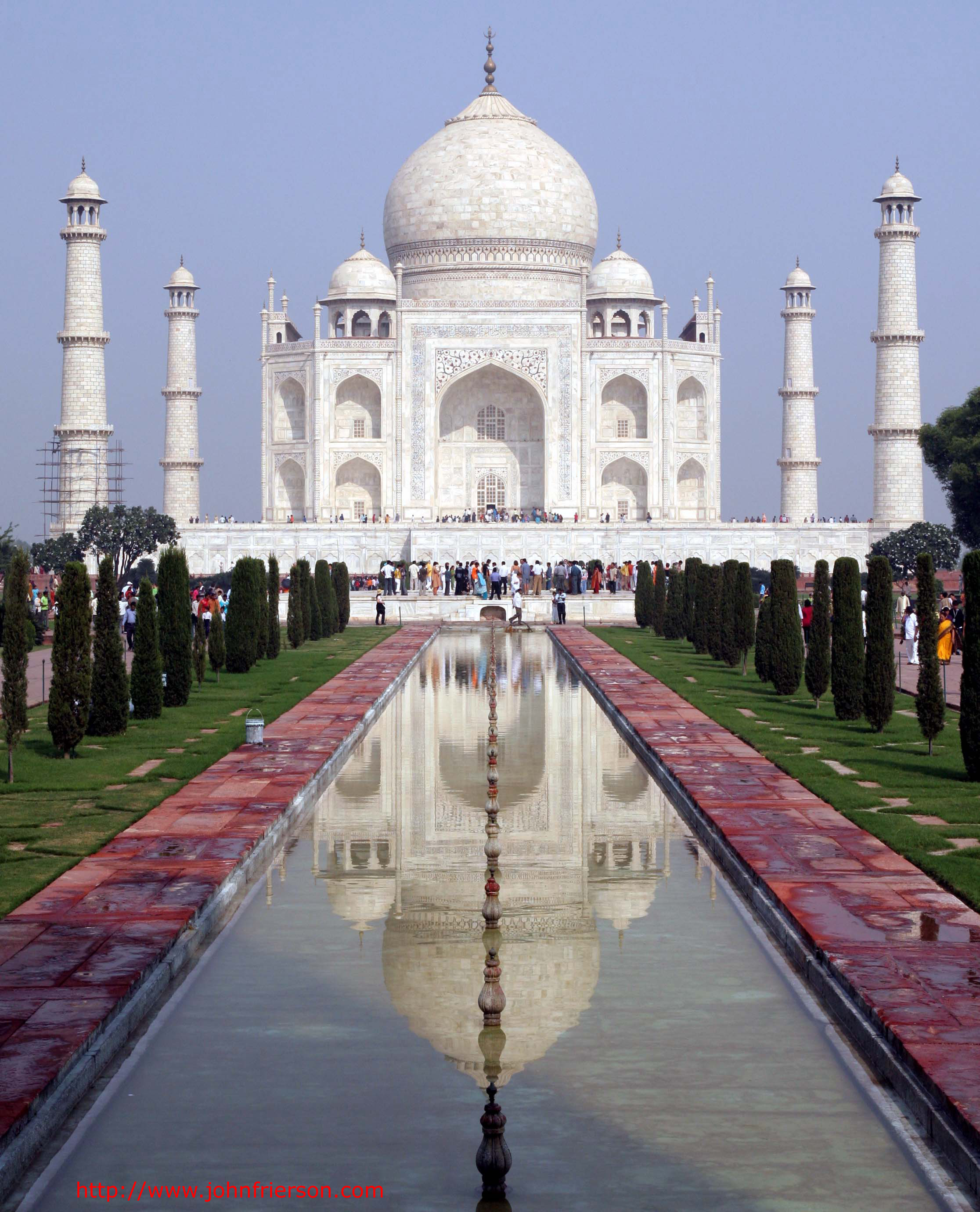
This is the story of an old trip, posted after someone asked for details. This was a 2-week independent itinerary arranged by Amazon Adventures. The tour operator worked out my transportation between cities, and arranged either for a guide or for me to join a local day tour in each city. ... Read the rest of this post...
Posted on 11/10/2006 5 Comments
November 05, 2006
Pikes Peak Video
... Read the rest of this post...
Posted on 11/05/2006 3 Comments
August 29, 2006
2006 Pikes Peak Marathon
I ran the 2006 Pikes Peak Marathon, which runs up a 7800ft elevation gain to Pikes Peak (14,110ft) and back down. Arkansas has traditionally boasted one of the largest contingents outside Colorado to participate in the races. This was the year that ... Read the rest of this post...
Posted on 08/29/2006 9 Comments
July 22, 2006
Barr Trail Mountain Race
On July 16, 2006, I ran the Barr Trail Mountain Race in Manitou Springs, Colorado. Twenty-three runners from the Rogue training group in Austin travelled to run the race, and most stayed a few days for additional training runs out of Barr Camp ... Read the rest of this post...
Posted on 07/22/2006 1 Comments
July 09, 2006
Austin Hill Comparisons
Comparisons of hill profiles in Ausin ... Read the rest of this post...
Posted on 07/09/2006 1 Comments
June 17, 2006
Grandma's Marathon
On June 17, I ran Grandma's Marathon in Duluth, MN. Grandma’s Marathon was not originally in my race plan for the year. My focus was to be first on the Freescale Austin Marathon, and then on the Pike’s Peak Marathon. But my parents decided to host a family gathering around this race ... Read the rest of this post...
Posted on 06/17/2006 0 Comments
